- idvsolutions.com

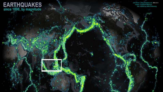
VIVAnews – Most parts of Indonesia are covered with the color of neon green on the earthquake map.
This map pinpoints the area prone to earthquakes of huge magnitude since 1898. The areas around the Pacific Ocean are considered the most dangerous. Overall, 203,186 spots of earthquake-prone area around the world are mapped.
The neon-colored map was made as a part of the mapping project initiated by IDV Solutions’ Manager, John Nelson, who works for a data visualization software manufacturer, IDV Solutions.
“I've been looking at really general sources of existential risk and visualizing them via the kitchen sink school of thematic mapping. So the earthquakes map was just a matter of time,” he writes on IDV blog.
"Here, data from NCEDC.org and the USGS and UC Berkeley have been sliced out into veneers based on magnitude, then glued onto and image that began it's life at NASA's Visual Earth and wrung into the Times projection (centered at the interesting bits)."
Nelson’s earthquake map documents the great earthquake in San Fransisco, USA that killed 3,000 people and last year’s disaster in Christchurch, New Zealand, which killed 185 people.
Nelson also mapped every tornado that has hit the United States in the last six decades.

Haru, Angelina Sondakh Ungkap Inspirasi Kebaikan Mendiang Mooryati Soedibyo
Pada masa mengemban gelar sebagai Putri Indonesia, Angelina Sondakh sangat dekat dengan Mooryati Soedibyo.